Urban–rural
Cities, countryside and the line between them
Finland in seven classes
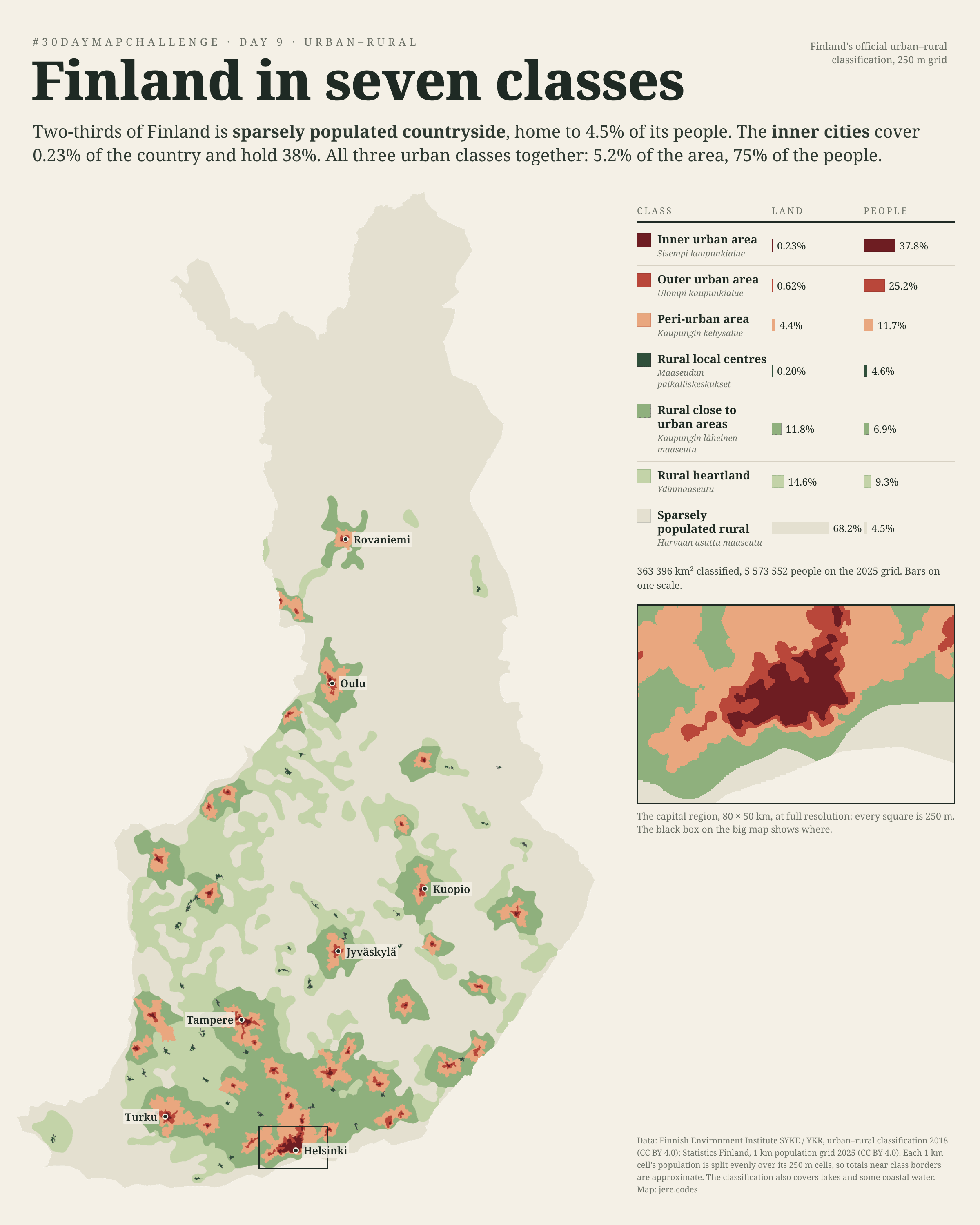
Finland has an official answer to the question “is this the city or the countryside?” for every 250 metre square of the country. The Finnish Environment Institute sorts each square into one of seven classes, from inner urban to sparsely populated rural. I put that grid on one map and counted who lives in each class.
Find your town
The same 250 m grid on a live map. Zoom in to see where a town's inner core gives way to its fringe, hover or tap to read a class, and switch classes off to see what's left.
Classes · tap to hide, double-tap to show only one
Showing 100.0% of the area and 100.0% of the people.
Go to
Two-thirds of the map, one in twenty-two people
The palest class, sparsely populated rural, covers 68% of the classified area and is home to 4.5% of the people. At the other end, the inner urban cores cover just 819 km², 0.23% of the area, and hold 37.8%. The three urban classes together are about a twentieth of the map and three-quarters of the people.
| Class | Area km² | Land | People | Share |
|---|---|---|---|---|
| Inner urban area | 819 | 0.23% | 2 106 281 | 37.8% |
| Outer urban area | 2 235 | 0.62% | 1 405 456 | 25.2% |
| Peri-urban area | 15 809 | 4.4% | 650 609 | 11.7% |
| Local centres in rural areas | 731 | 0.20% | 256 050 | 4.6% |
| Rural areas close to urban areas | 42 914 | 11.8% | 387 164 | 6.9% |
| Rural heartland areas | 53 163 | 14.6% | 516 499 | 9.3% |
| Sparsely populated rural areas | 247 725 | 68.2% | 250 520 | 4.5% |
Land is the share of the 363 396 km² the classification covers; people are the 5 573 552 residents on the 2025 grid.
How it was made
The classes come from SYKE's urban–rural classification (2018), drawn on the national 250 m grid: inner and outer urban areas and the peri-urban fringe around cities of more than 15,000 people, then rural local centres, rural areas close to cities, the rural heartland, and sparsely populated countryside. Population is Statistics Finland's open 1 km grid for 2025. Its finest open grid is 1 km, so each square kilometre's residents are split evenly over its sixteen 250 m cells. Totals near class borders are therefore approximate.
The classification covers lakes and some coastal water as well, so its area is a little larger than Finland's land and inland waters together. The country map averages the colours of the 250 m cells inside each pixel, so a small town tints its pixel instead of vanishing. The inset shows the capital region without averaging.
Data: Finnish Environment Institute SYKE / YKR, urban–rural classification 2018 (CC BY 4.0); Statistics Finland, 1 km population grid 2025 (CC BY 4.0).
Day 8 turned a half-empty mall into a town. More maps from the month are in the #30DayMapChallenge 2026 gallery.